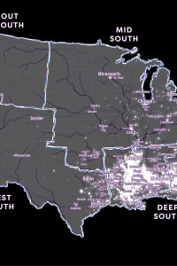
Chocolate Cities (2019)
Commissioned by Scalawag magazine to accompany Danielle Purifoy's review of Marcus Anthony Hunter and Zandria F. Robinson's Chocolate Cities. As I describe in the accompanying text:
This map draws on the geographic vision Marcus Anthony Hunter & Zandria F. Robinson lay out in Chocolate Cities: The Black Map of American Life to give one attempt. The map starts with some of the regions and key cities the authors highlight in their overview of the Black map. But I wanted also to foreground some of the smaller majority-Black cities and towns across the US which might not show up on a conventional map of the country, and so I drew in data from the US census to label incorporated places which the Census identified as majority-Black. The glow in the background highlights census blockgroups, tracts or designated places which had over forty percent of their population identified as Black (alone or in combination with other racial or ethnic identities). All census data was according to the 2012-2016 American Community Survey.
In some ways, this is a speculative cartography -- some of the named places are truly tiny population-wise, and the choice of what to name was often arbitrary -- but each of them, the many places highlighted but unnamed, and the many more which aren't even legible to the statistical viewpoint of this map, is a locus of the Black place-making which Hunter & Robinson argue is "the light toward both true civilization and broad liberation."

